The romance of the American road trip has lured travelers into their cars over the last century, offering a break from itineraries and access to wild landscapes across the west. These adventures also provide one of the only ways I can visit the far-flung places I love most.
They are places that are rapidly changing. From the coast to the mountains, the forest to the desert, California’s long drives offer a frontline view of the climate crisis.
This year, transformations were on full display after record-breaking winter storms wreaked havoc on landscapes already reeling from years of drought, wildfires and coastal erosion. While scientists are still debating whether the intensity was increased by human-caused climate change, they have long predicted events like these will worsen as the world warms.
So, in the midst of yet another landmark year, I set out in three directions from my home in the Bay Area – heading to the states’s north, east then south – to see how three popular routes were faring in the face of disaster.
Starting in the spring, I ventured to the Volcanic Legacy Scenic Byway in California’s north-east corner, and up toward Oregon, past burned skeleton trees and through rutted trails. As summer neared, I crossed over the Sierra Nevada, which runs along the state’s eastern edge and which was covered with snow unusually late in the season, before driving down the historic Highway 395, the backdrop to California’s historic water wars. As autumn arrived, I set out for the Pacific Coast Highway, where stretches of the scenic route through Big Sur were still cut off, months after the winter storms.
Still filled with beauty, these places are haunted by previews of what’s to come.
Fire, flood and drought along the Volcanic Legacy Scenic Byway
Fat raindrops thudded against my windshield as the wind picked up – the storm accompanying me on this long drive was far from over as I headed north.
It was the beginning of June and I was on my way to the Volcanic Legacy Scenic Byway, known for the ancient lava fields and the aftermath of eruptions that shaped its scenic lakes and peaks. Disasters of a different kind are now posing challenges to rural communities here as conditions flip between fire and flood.
In the months before my trip, California had been hit by a brutal wave of storms that washed out roads, submerged small towns and sent cascades of mud and debris down slopes damaged by wildfires. The rain pouring while I drove made clear the onset of spring had offered little reprieve.
Evidence of the wildfires that had torn through in recent years lingered in the brown patches of trees that dotted the vast greenery, serving as a haunting reminder that, despite the mist swirling around them, flames could ignite them again one day.
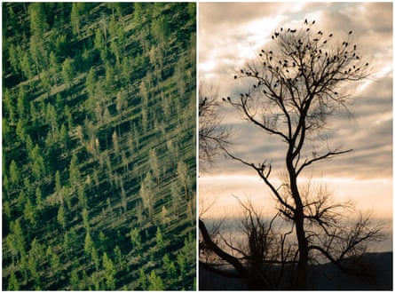
Even after the wet weather, the effects of prolonged drought are still at work along the border of California and Oregon. I awoke early the next day in the Klamath Basin, a region once dubbed the Everglades of the west for its abundant wetlands, most of which were drained or diverted as the area became an agricultural hub.
“We know how to fix it,” Jeff Mitchell, the former chair of the Klamath Tribes, told me with contagious optimism. He and other Indigenous tribes and organizations have shepherded the country’s largest dam-removal project along the Klamath River, which they hope will set the stage for a system-wide recovery.
It is just one piece of the puzzle – albeit a big one – and other threats still loom large. His words danced in my head as I crossed the border back into California and swung into a stop at the Tule Lake national wildlife refuge, an essential stopover for migrating waterfowl.
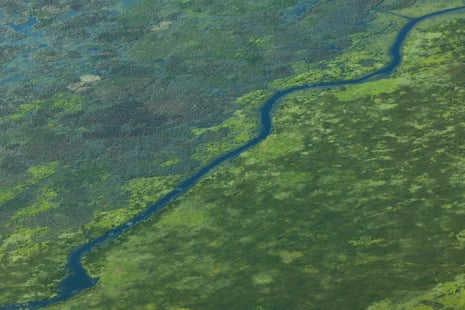
I walked into a meadow where hundreds of birds fluttered in the vegetation; this area once served more than 6 million as they made their long crossings north and south. Their numbers have been drastically reduced from decades of human development, but I was heartened by their calls rupturing the silence.
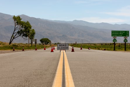
Continuing on through Lava Beds national monument, where the aftermath of ancient volcanic explosions shaped the land, more wildfire-charred trees made for a moody view against the rainfall as I passed closed campsites and blocked roads. Even access into Lassen Volcanic national park was still cut off due to damage from the winter storms.
I fell asleep that night thinking about how this wild place had been forged by violent volcanoes and the new chapter now being written. The aftermath of past disasters has grown beautiful in the centuries that followed, and I wondered how the future would view the ones we caused.
Epic snow and desert water wars on Highway 395
As summer approached, the Sonora Pass – a scenic route that climbs into the mountains north of Yosemite national park and over the steep slopes of the Sierra Nevada range – had only just opened after a 211-day closure. The mountains and towns tucked into them had been pummeled that winter and were still covered in snow.
Beyond those high-altitude peaks, I planned to descend into a different landscape altogether: California’s Highway 395, a route that stretches across more than 1,300 miles, dotted with hot springs and ghost towns. The part of the drive I did is known for its dramatic shifts in landscape, running along the eastern edge of the mountains near California’s border with Nevada and down into the high-desert terrain further south, passing both Mount Whitney, the highest point in the contiguous US, and North America’s lowest point in Death Valley.
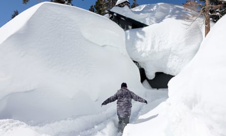
I set off with my boyfriend, Rob, and his trusty old Subaru Outback, packed with gear for a drive that would span ice-covered trails to scorching heat. The hours passed quickly as the view shifted from suburbs to ranch land to amber foothills, before giving way to trees and towering banks of snow that shimmered under the summer sun.
As we climbed up and over the range and descended to the valley, we watched landscapes emerge from the ice. It would make for a soggy sleep the first night, spent in one of the many campsites still sodden from snow melting from the mountains.

The next day would take us south along the 395, for quick stops along the boiling turquoise springs of Hot Creek geological site, and hikes up volcanic rock still laced in white. As we kept driving south and the temperature climbed, snow gave way to desert sage and dust as we bumped along the roads leading into Alabama Hills in search of a spot for our second night.
Set in an otherworldly terrain of rocks, this popular backdrop for films and television is also a well-known camping destination. The site was even busier than normal, due to nearby campsite closures – all the sites along the Whitney Portal had been affected by the rough winter – which had crowded far more campers onto the BLM land. As the sun slipped behind the Sierra range, we were still searching. It would be dark before we found a place to set up.
The next morning, we pointed our car toward Owens Lake, part of a once-vibrant basin that was drained in the 1920s to quench the thirst of Los Angeles. Today, much of the large lakebed is dry and dusty, but we heard rumors it was returning to life after being fed by strong runoff from the Sierra snow.
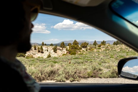
After what felt like hours winding on the two-lane road through endless desert marked by swollen streams, we saw the lake in the distance. We weren’t able to get up close, but it looked like a blue mirage, blurred by heat and surrounded with machinery. The dry lake had water.
We turned back on 395, heading south to discover more water history at Fossil Falls. We walked paths full of bristled vegetation and put our hands against the ghost of a waterfall that had once flowed into the valley.
There was just time for a quick picnic in the 105F (41C) heat before heading home. As we drove north, we thought about snow, heat and the effect a shift in water levels can have, contemplating the extremes felt along a single road in a single year.
Landslides, closures and coastal erosion on the Pacific Coast Highway
The Pacific Coast Highway, also known as PCH or Highway 1, is one of the world’s best-known drives. Millions of tourists descend on the road every year, especially a section that weaves through Big Sur, to admire the wild terrain where the mountains meet the Pacific.
But the thoroughfare is also beleaguered by landslides and coastal erosion. Tourism and traffic combined with the climate crisis have made it worse, leaving sections of the road closed for months at a time.
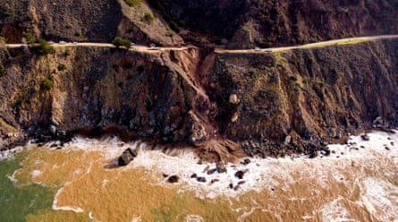
It’s rumored the highway has never been fully operational from north to south for more than a year since its opening in 1937. With its steep slopes and diverse geology, it has become a Sisyphean maintenance project. The winter storms caused more damage, as crumbling hillsides slid into the sea below and prompted yet another round of road closures.
By the fall, I’d been waiting for months for the stretch of PCH that connects Los Angeles and San Francisco to reopen. It was still ruptured about halfway down, so driving the full route would be impossible. Rob and I decided nonetheless to head for one of our favorite beach campsites by bypassing the closed parts and approaching from the south, adding roughly 200 miles to the trip.
Those extra miles made for a late-night arrival on our first night. We set out early the next morning, with a surfboard and beach bag under each arm, down the steep winding path to the water.
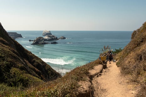
Signs along the trail, which was rutted and wet, warned of volatile conditions: “Entering winter storm damage area. Enter at your own risk.” Beachgoers blithely ambled by.
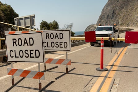
That afternoon we drove on toward the site of the landslide that had closed the highway for so long. The road ended abruptly at Limekiln state park, blocked by signs and a single man in a truck, whose job was to tell tourists to turn around – and make sure they actually did. He told us there was no end in sight to the work, as the softened earth continued to shift and hamper roadworks.
The route was covered with construction equipment that sat idle on the sun-swept cliffs, next to freshly churned piles of dirt. With so many campsites closed, crowds of cars could be seen parked on the beach south of the slide where dispersed camping is allowed.
The prolonged closures haven’t just been tough for visitors. They’ve made life harder for local residents and businesses that depend on tourism.
We’d planned for a last breakfast overlooking the Pacific, at a seaside eatery called Whale Watchers Cafe. We arrived to find chairs still propped on tables, the dining room closed and quiet. The attached store was selling goods to locals and the occasional camper, but when we asked a woman behind the counter if they planned to reopen for breakfast, she shook her head and said she was unsure.
At that point, she said, it was too hard to keep it going.
Wild places have always been forged by catastrophic environmental shifts. Now spurred by human intervention, these shifts seem more sinister.
Still, after these three drives, like Mitchell, the tribal chair I met in the Klamath Basin, I can’t help but hold onto optimism.
“Is there going to be some pain? Probably,” he had said as we talked about adjusting lifestyles to the new climate normal. He was speaking about Klamath, but his words felt applicable to the places on display through my car window.
“It is the most beautiful country in the world,” he said. “I don’t see anything here we can’t fix if we put our minds to it.”

